Hilbun Family Land Records in North Carolina prior to 1800
by Joy H Mohr
INTRODUCTION:
The earliest record of my 4th great-grandfather, Frederick Hilbun, is from a land record in Burke County, Georgia in 1788. He was one of four Hilbun/Hilburn men, Holliman, James and William, documented living there from 1788 to 1792. Holliman Hilburn was likely the oldest as he was the first and only one to purchase land during those years. (Frederick did purchase land after 1800). It is likely these Hilburn men were born between the years 1766-1772.
According to census and Bible records, Frederick Hilbun was born in North Carolina in 1768, but the mystery remains; who were Frederick’s parents? Since he was born in 1768, his father would have likely been born before 1747. Therefore, my research has focused on the Hilburn adult men recorded as living in North Carolina during the decade in which he was born. Those men who meet that standard were John Hilburn, born in 1734 or earlier, Vaughn Hilburn, born at or before 1742, and Hamblin Hilburn and William Hilburn who would’ve both been born by 1746. The calculations of their birth year are based on their first known land purchase as they had to have been 21 years of age at that time. This document is an attempt at learning about those Hilbuns, where they lived, and if a connection to Frederick can be established.
Thanks to records that still exist from the 1700’s, I have been able to find several Hilbun land records. All land owned by Hilbuns in North Carolina prior to 1793 was in Duplin/Sampson County with one exception! Vaun Hilbern was granted land in Dobbs County in 1763 and owned it for approximately 20 years. Vaun, also recorded as Vaughan, Vaughn, and Vann, was enumerated on a roster of Edgecombe County’s militia during the Spanish Alarm in 1748 which is the first record of a Hilbun (often spelled Hilburn, and various other spellings) in North Carolina. A John Hilburn was also in Edgecombe County in 1754 as he was recorded as a chain carrier on a land survey for John Proctor. The following year, John Hilburn bought land in Duplin but seemed to have moved to Bladen County by 1769. It is believed that John, Vaughn and possibly Hamblin were sons of Vaughn Hilburn who purchased land in Isle of Wight, Virginia in 1730.
For almost 40 years, from 1755 through 1793, Hilbuns owned land in Duplin County! It is likely that Frederick was born in Duplin. In 1786, the area in Duplin where Hilbuns owned land became part of Sampson County. The Hilbuns who owned land in Duplin /Sampson were John Hilbun, Hamblin Hilburn, Patience Hilburn and Vaughn Hilburn. Two other Hilbuns, Henry Hilburn and William Hilbun, were recorded as witnesses to land records in Duplin.
Frederick Hilbun was in Georgia as early as 1788, yet Hamblin and Vaughn’s families are well documented as continuing to live in North Carolina after 1800; therefore, it is believed that Frederick Hilbun’s father likely left North Carolina prior to or during the Revolutionary War. While I still have not found any record proving that these North Carolina Hilbuns from the 1700’s were my ancestors, I believe they were, primarily based on DNA evidence. A DNA connection has been established between my father and a descendant of Hiniard Hilburn who was born in Columbus County, North Carolina in 1799. His father is unknown, but he was related to Hilburns in Columbus who descend from Hamblin Hilburn. Early records suggest that Hamblin was related to John and Vaughn Hilburn.
Therefore, a thorough examination of North Carolina land records during this time could possibly shed light on this theory. Again, this study concentrates on Hilbun land records prior to 1800. There are numerous Hilbun land records after 1800, primarily in Bladen, Brunswick, Columbus and Robeson Counties.
Sources and Methods.The source for this information has primarily come from the land records available online at Sampson County’s Register of Deed’s office (www.sampsonrod.org). The biggest help in finding the location of the lands owned by Hilbuns has come from the Duplin-Sampson Land Grant Maps compiled by Thomas Mitchell Byrd, found online at http://www.sampsonhistory.org, the site for the Sampson County Historical Society. These maps have proven to be extremely valuable in this research! Mr. Byrd describes the maps:
“The Duplin Sampson Land Grant Maps is a series of 46 maps that show the first identifiable property owners in these two adjoining North Carolina counties.” Each map covers the same area & carries the same name as the quadrangle maps of the United States Geological Survey (USGS), the official mapping agency of the federal government. At least one waterway is cited as a reference in nearly every grant, & these waterways were the principal guide in mapping the grants. “The maps show the names of the grantees, along with the acreage, location, configuration & date of their grant, & the file number in North Carolina State Archives under which information on the grant can be found. “
citation is above
Each quad map is seven miles east to west and 8.5 miles north to south. Based on this, the Hilbun owned lands were all within approximately 8- 10 miles of another. The Hilbuns owned land which is in present day Sampson County, south of Clinton and northeast of Ingold. The land they owned was within a 10-mile radius.
The records listed here are lands bought and sold by Hilbun/Hilburn men, and one Hilburn woman in North Carolina during the 1700’s. In addition to the Duplin/Sampson lands, I’ve also included records of Hilbun owned lands in Dobbs and Wayne Counties. In order to research and understand these lands in comparison with each other, I have assigned a number to each land purchase. In addition, land records in which a Hilbun is a chain bearer, or an adjoining landowner are also included. The names will be written in this document as they are spelled in the records.
The basic information for each land transaction will be presented, along with related records and an analysis of the information.
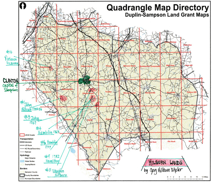
Map showing the locations of Hilbun lands. Most of the Hilbun lands were south of Clinton and north of Ingold.
SOURCE: Quadrangle Map Directory- Duplin-Sampson Land Grant Maps by Thomas Mitchell Byrd and Donald F. Carter. 2013.
HILBUN LAND RECORDS
HILBUN Land Record #1     Duplin        Bonnetsville Quadrangle
1755 Aug 19.      John HILLBUN bought 100 ACRES from John ROE
LOCATION: south side of Little Cohary (presently located southeast of Roseboro)
PERSONS NAMED:    Jeremiah BULLARD- adjoining landowner (AL)
                  John BERRY- witness
ORIGINAL PATENT OWNER:   John ROE
OWNED THIS LAND:    seven months
DETAILS: John Roe, planter, of Hanover County, North Carolina sold land to John HILLBUN, of Duplin County, for 15 pounds Virginia currency. The land is described as one tract of land & plantation lying on the south side of Little Cohary … to a red oak at the head of a valley between Jeremiah Bullard & John Hilbun. The witnesses were John Berry and Jeremiah Bullard. The deed was registered October 9, 1755. Sampson Register of Deeds (ROD) Book 2, p. 284-285
RELATED LAND RECORDS: The following day, John Roe sold 100 acres of adjoining land to Jeremiah Bullard, of Duplin for 12 pounds Virginia. The land was one tract of land & plantation lying on the south side of Little Cohary …up to a maple in Allums Branch then to Little Cohary Swamp, & witnesses were John Berry & John Hillbun. Book 2, p. 285-286.
On April 14, 1759, Hilburn is mentioned in a deed from John Brown to John Williams in which Brown sold land “west of Little Coharie Creek below Hilburt’s line.” I assume this is John Hilburn as there is no other similar name in that area, & John Brown was known to Hilbun as he was a witness in the sale of his land. Sampson ROD: Bk 1, p 215
In 1768, Jacob Lockarman, sold landto John Parker. He later is on a Revolutionary War muster with Hamblin Hilburn. The land was described as on “the west side of Little Cohary Crk, beginning below Hilbert’s line,” a tract of land to John Brown in 1756 & from John Brown to J. Williams to Lockerman. Witnesses: John Williams, Rich’d Sessums. Bk 1 p. 214-5
ORIGINAL PATENT: John Roe was granted 200 acres on Little Cohery Creek, on March 31, 1755; this Grant #148 is found in Book 2, p. 120. It was described as on Little Cohery … running through the marsh …to a maple in Allumes and back to Little Cohery Swamp. It was surveyed for John Roe on June 18, 1753 by T. Skibbow D. S.
SALE OF LAND: On March 2, 1756, John HILBUN of Duplin sold 100 acres & plantation, to John Parker of Duplin for 15 pounds. The land was on the south side of Little Cohary beginning in the swamp … to the head of a valley joining Jeremiah Bullard. Within the deed it states that Hilbun is “the true sole & lawful owner of the above Bargained premises”& he is “lawfully possessed of the same in mine own proper right as a good perfect & absolute estate of inheritance in Fee Simple.” The only stipulation in the deed was the owner must pay the annual quit rents. The witnesses were John Berry & John Brown. Book 2, p. 346
ANALYSIS: John had to have been born in 1734 or earlier. He & Jeremiah Bullard bought adjoining land & served as each other’s witness, so it is likely they were related or good friends. Seven months after buying this land, he sold it. This is the LAST record of John until 1766 when he witnessed a deed from Rogers to Rackly, AND was an adjoining landowner near Six Runs. As mentioned, in 1768, Lockarman sold land to Parker described as being below “Hilbert’s line”. Was this simply a reference to Hilburn’s past land, or did he still own land in that area in 1768? Where was he for ten years??
HILBUN LAND RECORD #2. Dobbs County Walstonburg Quad
23 Sep 1763. Vaun HILBERN received a land patent for 195 acres. Location: on south side of Nahunty (area later became Wayne County)
PERSONS NAMED: John ELLIOT- AL (adjoining landowner); Robert FELLOW- AL; John WORRELL- AL; Rich’d WORRELL- CB (Chain Bearer); John ROWELL- CB
ORIGINAL PATENT OWNER: Vaun Hilbern
OWNED THIS LAND for: possibly 16 years; sold it between 1777-79
DETAILS: On September 23, 1763, a patent was entered in Dobbs County, North Carolina for a 195-acre survey for Vaun Hilbern on the south side of Naughhunty (also spelled Nauhunty). This land joined John Elliot and Robert Fellow’s lines & ran south to John Worrell and John Elliot’s corner. The chain bearers were John Rowell and Rich’d Worrell. This grant #66 was issued on 12/21/ 1763 & found in Book 8, p. 7. Source: Ancestry.com, North Carolina Land Grant Files, 1693-1960. Original data: N. C. Land Grants, North Carolina Archives.
In 1758, Dobbs County was formed from the eastern portion of Johnston County. Old Dobbs included today’s Wayne, Greene, Lenoir and small portions of several other counties.
RELATED LAND RECORDS: Vaun Hilbern was the first of the Hilbuns to be recorded in North Carolina as he was on a roster of the 1748 Edgecombe County Militia from John Sherrard’s company. This roster is from the State Records of North Carolina, Volume 22, pages 282-283. Other names associated with Hilbun are also on the roster are (listed in order) John Rowell, John Worrel Sr., Richard Warrel, John Worrel, Jr., Vann Hilbern, Elisha Woodard and Thomas Woodard, Jr. Elisha Woodard later owned land in Duplin joining Hamblin Hilburn’s land on Buckhorn Creek. I suspect that this Vaun Hilbern in 1748 was the Vaughan Hilburn from Isle of Wight, Virginia.
In Edgecombe County in 1754, a John Hilburn was a sworn chain carrier on a land survey for John Proctor. The land was on Tyancoky Swamp and bordered Thomas Holliman’s land. Tyancoky Swamp is in the Pinetops Quadrangle. The distance between Tyancoky, now referred to as Cokey Swamp, and Nahunta (35.5126605, -77.7324773) is approximately 20 miles.
SALE OF LAND: The exact date of sale is unknown. According to page 281 in Old Dobbs County Book 11, January 1777 – April 1779, Vaughn Hillburn sold land to Samuel Pike. Details of this transaction are not known as the original deeds were lost, although the following record sheds some light on the 195 acres Vaughan received in 1763: “On May 31, 1784 Sam Pike gave to son, 100 acres on the south side of Naughhunty Swamp, being part of a tract granted to Vaun HILLBORN on 21 Dec 1763. Book 2, 1784-1785.
ANALYSIS: Based on this 1763 land record and on other records, there is a preponderance of evidence to suggest that Vaughn and the Worrells were related by marriage. John Worrell was an adjoining landowner and it’s believed that Worrell was Vaughn’s father-in-law; Worrell’s 1788 will names an Elizabeth Hilburn as an heir. Also, two Worrell family members were named in Vaughn Hilburn’s 1830 estate in Hinds County, Mississippi after his death.
Vaun Hilbern, Sr. was in Edgecombe in 1748 while John was there in 1753.  It is likely that Vaun Jr. was the one who bought land in 1763.   It is also believed that this Vaun Hilburn bought land in Sampson County in 1790 and is enumerated in the 1790 Sampson census with a large family.

TO BE CONTINUED!!!
